India’s local-first travel ecosystem — book local operators direct, zero commission

Satopanth Lake Trek
Chamoli, Uttarakhand

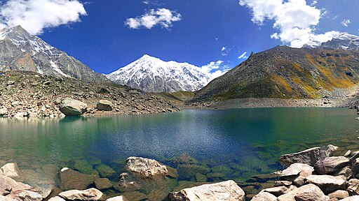
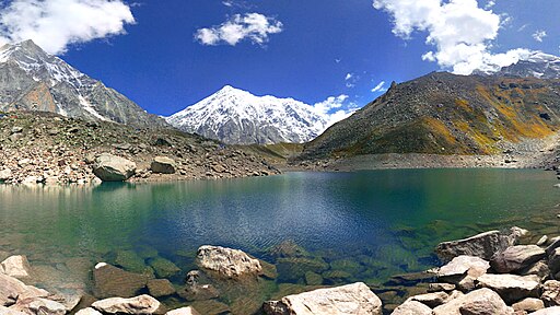
The Satopanth Lake Trek is a mesmerizing high-altitude trek located in the Chamoli district of Uttarakhand, India. Situated at an elevation of approximately 15,200 feet (4,630 meters), Satopanth Lake is a stunning glacial lake revered for its pristine beauty and spiritual significance. Nestled amidst the majestic peaks of the Garhwal Himalayas, this trek offers a perfect blend of adventure, nature, and tranquility, making it a favorite among experienced trekkers and nature lovers alike.
The trail to Satopanth Lake is renowned for its diverse and dramatic landscapes. It begins with dense forests of pine and rhododendron, gradually giving way to alpine meadows and rugged terrain as the altitude increases. Along the way, trekkers are treated to spectacular views of iconic Himalayan giants such as Nanda Devi, Kamet, Trisul, and Chaukhamba. The lake itself, crystal-clear and surrounded by towering snow-capped peaks, presents a surreal and almost otherworldly scene that captivates every visitor.
What makes the Satopanth Lake Trek truly unique is its combination of natural grandeur and cultural depth. The route passes through remote villages where the warm hospitality of the local Garhwali people offers a glimpse into mountain life. Trekkers also encounter ancient myths and legends tied to the lake, which is considered sacred in Hinduism and is believed to be a spot where the gods descended to bathe.
While the trek is challenging due to its high altitude and steep sections, it is well-marked and can be completed by moderately experienced trekkers with good fitness. The best seasons to undertake this journey are from May to June and September to October, when the weather is clear and the trails are accessible without heavy snow.
More than just a physical expedition, the Satopanth Lake Trek is a spiritual and sensory escape. It provides an opportunity to immerse oneself in the silence of the Himalayas, witness breathtaking landscapes, and experience the profound connection between nature and spirituality. For trekkers seeking a route that combines awe-inspiring scenery, cultural richness, and a test of endurance, Satopanth Lake Trek is an unforgettable adventure that promises both challenge and serenity.



Quick view — Satopanth Lake Trek
📍 Location: Chamoli district, Uttarakhand, India
🗻 Elevation: Approximately 4,600 meters (15,092 feet)
🧭 Trek Distance: Total around 45–50 km (including return)
⏳ Trek Duration: 6 to 8 days (depending on itinerary and acclimatization)
🚶♂️ Difficulty Level: Moderate to Difficult – suitable for experienced trekkers due to altitude and rugged terrain
📅 Best Time to Visit:
May to mid-July and September to mid-October
🌦 Weather Conditions:
- Summer: 5°C to 15°C
- Monsoon: Frequent landslides, not recommended
- Autumn: -5°C to 10°C (cold but stable weather, great visibility)
- Winter: Not accessible (heavy snow, trail blocked)
🗺️ Trek Route (On Foot Only):
Mana Village ➜ Lakshmi Van ➜ Chakratirth ➜ Satopanth Tal ➜ Return via same route
📌 Trek Details (In Brief):
🚩 Mana Village (0 km): The last village before the Indo-Tibetan border, known as the “last Indian village.”
🌲 Lakshmi Van (~9 km): Alpine forests, mythologically believed to be where Goddess Lakshmi meditated.
🏞️ Chakratirth (~14 km): Meadow shaped like a chakra; natural beauty combined with spiritual calmness.
💧 Satopanth Lake (~22–25 km): Glacial lake at high altitude, shaped like a triangle. Believed to be visited by Brahma, Vishnu, and Mahesh. Crystal-clear water and magnificent views of Chaukhamba and Neelkanth peaks.
⛺ Camping Spots: Lakshmi Van, Chakratirth, and near Satopanth Tal (only if weather permits).
📌 Facilities on the Route:
No tea stalls or shops after Mana. Carry own food, stove, and tents. Mules and porters available from Mana village.
⏰ Trek Timing:
Usually starts early around 6:00 AM to avoid weather shifts; night trekking is highly discouraged.
🛕 Cultural & Mythological Significance:
- Satopanth Tal is believed to be the path taken by the Pandavas on their way to heaven.
- Local legends say the Trimurti (Brahma, Vishnu, and Mahesh) meditate at the lake on auspicious days.
- The trail is rich in ancient Himalayan stories and legends.
📶 Mobile Network Availability:
Only available in Mana (patchy for Jio/BSNL); no network beyond. Satellite phone with guide recommended.
🏧 Nearest ATM:
Available in Badrinath (~3 km before Mana). No ATM further.
🏥 Medical Facilities:
Basic facilities in Badrinath; carry a full medical kit and consult a doctor about altitude sickness prevention before trek.
📞 Emergency Numbers:
Uttarakhand Helpline: 112
Badrinath Police: +91-1372-222221
Local trekking agencies or guides should be informed in advance.
🌄 Scenic Beauty:
Stunning views of Chaukhamba, Neelkanth, and Balakun peaks. Glacial streams, rare alpine flora, and the divine Satopanth Tal. Perfect setting for peace-seekers and photographers.
🐾 Wildlife:
Possible sightings of Himalayan fox, blue sheep (bharal), snow partridges, and rare high-altitude birds.
📸 Photography Tips:
Best shots early morning near lake when sunlight hits Chaukhamba. Tripod recommended due to cold winds. Sunset at Chakratirth is photogenic.
🐎 Pony and Porter Services:
Available till Lakshmi Van. Beyond that, porters preferred due to steep and narrow trail.
🏕 Accommodation:
Lodges/guesthouses available in Badrinath and Mana. Tent accommodation required beyond Mana; advance planning a must.
🚁 Helicopter Service:
Nearest helipad at Badrinath. No direct service to the lake.
🧠 Tips & Precautions:
- Acclimatize in Badrinath/Mana for 1 day before starting.
- Carry ample warm clothing and a high-altitude medical kit.
- Do not litter. Maintain eco-sensitivity of the pristine trail.
- Local guides are highly recommended for navigation and safety.
Key Attraction — Satopanth Lake Trek
Satopanth Lake
A sacred, triangular-shaped glacial lake believed to be the meditation spot of Brahma, Vishnu, and Mahesh. Its crystal-clear waters and mythological aura make it truly divine.
Path of the Pandavas' Heaven Journey
As per legends, this is the very path taken by the Pandavas on their way to heaven, adding deep spiritual and historical significance to the trek.
Views of Chaukhamba, Neelkanth & Balakun Peaks
The trail offers majestic views of snow-covered Himalayan peaks that dominate the skyline and uplift the trekking experience.
Lakshmi Van
A dense forest believed to be the place where Goddess Lakshmi meditated. It is known for its tranquility and ancient deodar and bhojpatra trees.
Chakratirth
A circular, lush meadow ideal for peaceful camping and meditation, surrounded by towering peaks and serenity.
Mana Village
The last Indian village near the Indo-Tibetan border. It offers rich Himalayan culture, mythology, and traditional lifestyle insights.
Rare Himalayan Wildlife
Chances to spot Himalayan monal, blue sheep (Bharal), and other high-altitude wildlife along the trail.
Heaven for Photography
Reflective waters of the lake, sunrise/sunset hues, alpine landscapes, and starry night skies – perfect frames for any photographer.
Pure Camping Experience
Away from touristy crowds, the trek offers raw and peaceful Himalayan camping amidst nature’s silence.
Blend of Adventure and Spirituality
A journey that offers physical thrill, mental peace, and spiritual connection – all in one unforgettable trek.
Itinerary — Satopanth Lake Trek
🗓️ Satopanth Lake Trek Itinerary (7 Days)
📍 Starting Point: Rishikesh
📍 Trek Start Point: Mana Village (near Badrinath)
🥾 Trek Type: Moderate – High Altitude
🕉️ Total Altitude: ~4600 meters
🚌 Day 1: Rishikesh ➝ Joshimath
- Distance: ~255 km
- Travel Time: 9–10 hours (via road)
- Stay: Hotel/Guesthouse in Joshimath
- Highlights: Drive along the Alaknanda River, pass Devprayag, Rudraprayag, and Karnaprayag.
🚌 Day 2: Joshimath ➝ Badrinath ➝ Mana Village (Acclimatization Day)
- Distance: ~45 km (Joshimath to Badrinath by road), ~3 km trek to Mana
- Stay: Guesthouse/Homestay in Mana
- Highlights: Visit Badrinath Temple, Vasudhara Falls, Bhim Pul, and explore India's last village – Mana.
- Purpose: Acclimatization at 3,200+ meters altitude
🥾 Day 3: Mana ➝ Lakshmi Van
- Trek Distance: ~9 km
- Time: 5–6 hours
- Altitude: ~3,600 m
- Stay: Campsite at Lakshmi Van
- Trail Type: Moderate ascent through rocky terrain and river crossings
- Highlights: Forests, Alaknanda river views, peaceful camp by nature
🥾 Day 4: Lakshmi Van ➝ Chakratirth
- Trek Distance: ~10 km
- Time: 6–7 hours
- Altitude: ~4,200 m
- Stay: Camping at Chakratirth
- Highlights: Meadows, glacial streams, and views of Chaukhamba & Neelkanth peaks
🥾 Day 5: Chakratirth ➝ Satopanth Lake ➝ Return to Chakratirth
- Trek Distance: ~10 km (round trip)
- Time: 6–7 hours
- Altitude at Lake: ~4,600 m
- Stay: Camping again at Chakratirth
- Highlights: Spiritual Satopanth Tal, snow-capped reflections, pure silence, photo ops
🥾 Day 6: Chakratirth ➝ Mana ➝ Badrinath ➝ Joshimath
- Trek + Drive Distance: ~10 km trek + ~45 km drive
- Time: 5 hours trek + 2 hours drive
- Stay: Hotel in Joshimath
- Highlights: Return trek and relaxation
🚌 Day 7: Joshimath ➝ Rishikesh
- Distance: ~255 km
- Time: 9–10 hours
- Stay: Your onward plan (Rishikesh or Haridwar)
- Highlights: Final Himalayan goodbye via scenic road drive
🏕️ Optional Add-Ons:
- Meditation session at Satopanth Tal 🧘♂️
- Visit Tapt Kund or Neelkanth Peak base (if time allows)
- Local shopping in Mana for woolen and herbal products
📌 Important Notes:
- Get permits from forest department before trek
- Acclimatization is must; AMS (Acute Mountain Sickness) risk is present
- Trek is non-commercial, so carry own supplies, guide & camping gear
- Best season: May–June & Mid-September to October
How to reach — Satopanth Lake Trek
🛣️ By Road
Nearest Major City: Rishikesh or Haridwar
Route: Haridwar → Rishikesh → Rudraprayag → Karnaprayag → Joshimath → Badrinath → Mana Village (Starting point of the trek)
Last Motorable Point: Mana Village (approx. 3 km from Badrinath)
Mana is known as the last village before the Indo-Tibet border.
Parking at Badrinath/Mana:
- Paid parking is available near Badrinath and Mana village.
- Charges typically range between ₹100 to ₹200 per day.
- Private vehicles and taxis can reach till Mana; from here, trek begins.
🚶♂️ Trek to Satopanth Lake (Approx. 50–55 km round trip)
Route: Mana → Lakshmi Van → Chakratirth → Satopanth Tal
Trek Segments:
- Mana to Lakshmi Van (9 km): Gradual climb through alpine forest and river trail
- Lakshmi Van to Chakratirth (10 km): Steeper ascent through rocky terrain and moraine paths
- Chakratirth to Satopanth Lake (6 km): High-altitude zone, challenging climb with spectacular views
📝 Trek Note:
- This is a high-altitude trek (max. ~4,600 m) with glacier patches and unmarked trails – guide is strongly recommended
- Porters and mules are available till Lakshmi Van or Chakratirth
- Trek is non-commercial – must carry tents, food, and essential gear
🚁 By Helicopter
- No direct helicopter to Mana or Satopanth
- Helicopter services are available up to Badrinath during yatra season (May–June & Sept–Oct)
- Bookings via GMVN or authorized agencies only
- From Badrinath, Mana is just 3 km by road (trek starts here)
🚆 By Train
Nearest Railway Stations:
- Haridwar (~275 km from Badrinath)
- Rishikesh (~255 km from Badrinath)
From these stations:
→ Take a bus/shared taxi to Joshimath, then a taxi to Badrinath/Mana
✈️ By Air
Nearest Airport: Jolly Grant Airport, Dehradun (DED)
Distance to Badrinath: ~270–280 km by road
🛻 From Airport:
- Hire private taxi or shared transport to Joshimath/Badrinath
- Buses also available till Joshimath from Rishikesh
🚌 Bus Services
Regular buses available from Haridwar and Rishikesh to Joshimath
Operators:
- Uttarakhand Transport Corporation (UTC)
- Private Operators
Starting Points:
- Haridwar Bus Stand
- Rishikesh ISBT
Destination: Joshimath
From Joshimath → Taxi to Badrinath → Short drive to Mana village
🕓 Departure Timings:
- Most buses start between 4:00 AM to 6:00 AM
- Reach Joshimath by evening
⏱️ Duration:
- 10–12 hours (via Devprayag, Rudraprayag, Karnaprayag, Nandprayag)
🚌 Types of Buses:
- UTC Roadways Buses
- Deluxe / Semi-Deluxe Private Buses
- Shared jeeps and taxis also available
🎫 Ticket Booking:
- UTC buses: utconline.uk.gov.in
- Private: RedBus, MakeMyTrip, Paytm etc.
🔖 Important Tips:
- Best Trek Season: May–June & September–October
- Book travel and stays in advance during peak season
- Carry cash – very limited ATM availability beyond Joshimath
- Start early from Rishikesh/Haridwar to avoid night travel
- Keep buffer day(s) – hill roads may be affected by weather/landslides
- Trek is physically demanding – ensure proper fitness & acclimatization
Permits and Registration — Satopanth Lake Trek
✅ Is a Permit Required?
Yes, a permit is mandatory for the Satopanth Lake trek as it falls within the Nanda Devi Biosphere Reserve area. Trekkers must carry the permit throughout the trek.
📍 Where to Get the Permit?
Permits can be obtained from:
- Forest Department Office, Joshimath
- Tourism Office, Joshimath
If trekking with a registered tour operator or local guide, they usually arrange the permits on your behalf.
💳 Documents Required:
- A valid government-issued photo ID (Aadhar card, Passport, Voter ID, etc.)
- 2 passport-size photographs
- Medical fitness certificate (recommended especially for high-altitude treks)
💰 Permit Charges:
- Entry Fee (Indians): Approximately ₹150–₹250 per person
- Entry Fee (Foreigners): Approximately ₹700–₹1000 per person
- Camping Charges (if camping inside forest zones): ₹50–₹150 per tent per night
- Garbage Deposit (refundable): ₹500–₹1000 per group (if applicable)
Note: Charges may vary slightly depending on season or updated forest policies.
📅 Registration Process:
- Visit the Forest Department or Tourism Office counter in Joshimath.
- Submit the required documents and pay the fees.
- Collect the permit slip, which must be carried during the trek.
- You may be required to show your permit at checkpoints along the route (such as Mana, Laxmi Van).
❗ Important Tips:
- Carry your permit at all times during the trek.
- Solo trekking is not advised; in some seasons, trekking without a guide is not allowed.
- Follow Leave No Trace principles — carry back all non-biodegradable waste.
- Avoid plastic bottles and polythene bags, as they may be restricted in eco-sensitive zones.
Difficulty Level & Fitness Requirements — Satopanth Lake Trek
🧗 Difficulty Level:
The Satopanth Lake Trek is considered a moderate to difficult trek. It is suitable for trekkers who have some prior trekking experience and good fitness levels. The trek involves steep climbs, rough and rocky terrain, and high-altitude trekking, making it physically challenging.
- Trail Type: Mostly rough, rocky, and uneven trails passing through alpine meadows and glacier areas. Some sections may have snow and ice.
- Altitude: The highest point, Satopanth Lake, is at approximately 4,600 meters (15,091 feet). Due to this high altitude, there is a higher risk of altitude sickness, which can be managed with proper acclimatization.
- Terrain: Mixed terrain including rocky paths, snowy patches, and alpine meadows.
- Weather Conditions: Weather can be very cold, especially during early and late trekking seasons, with common snowfall.
💪 Fitness Requirements:
To comfortably complete the Satopanth Lake Trek, trekkers should:
- Have good cardiovascular endurance to handle long hours of trekking (6–8 hours daily) on steep and rough terrain.
- Be capable of continuous walking for 6–8 hours each day on varying difficult terrain.
- Be able to tolerate altitude changes and acclimatize gradually.
- Ideally, engage in pre-trek physical preparation such as regular walking, jogging, stair climbing, and stamina-building exercises.
⚠️ Who Should Attempt This Trek?
- Suitable for: Experienced trekkers or those with strong fitness levels looking for a moderate to difficult high-altitude trek. Nature lovers and adventure seekers who want a challenging Himalayan trekking experience.
- Not recommended for: Complete beginners, people with serious heart, lung, or joint issues, or those unaccustomed to physical exertion at high altitudes.
🧘 Tips for a Safe Trek:
- Stay well-hydrated and eat nutritious food.
- Take adequate time to acclimatize at each stage of the trek.
- Inform your guide about any health issues.
- Carry basic medications for altitude sickness and fatigue.
- Listen to your body and avoid pushing too hard if you feel discomfort.
- Follow Leave No Trace principles—carry back all non-biodegradable waste like plastics and avoid littering.
Backpack — Satopanth Lake Trek
🧳 Clothing
- Waterproof and windproof jacket
- Warm fleece or insulated jacket
- Lightweight trekking pants and thermal leggings
- Moisture-wicking t-shirts and innerwear
- Extra pairs of socks (preferably wool or quick-dry)
- Gloves, woolen cap, and neck warmer/scarf
- Comfortable trekking shoes with good grip
- Sandals or flip-flops for campsite use
🛌 Sleeping & Camping Gear
- Lightweight sleeping bag (rated for cold weather)
- Sleeping mat (optional, for extra comfort)
- Small travel pillow (optional)
🍽️ Food & Hydration
- Reusable water bottle or hydration bladder (at least 2 liters capacity)
- Energy bars, dry fruits, nuts, and snacks
- Electrolyte powder or tablets
- Lightweight utensils (if camping independently)
🧰 Essential Gear
- Daypack for carrying essentials during daily trek
- Trekking poles (highly recommended for support)
- Headlamp or flashlight with extra batteries
- Sunglasses (UV protection)
- Sunscreen and lip balm with SPF
- Personal first aid kit (bandages, antiseptic, painkillers, altitude sickness tablets)
- Toiletries (toothbrush, toothpaste, wet wipes, biodegradable soap)
- Quick-dry towel
- Passport/ID, permits, and photocopies
📱 Electronics & Miscellaneous
- Mobile phone and power bank
- Camera with extra memory cards and batteries
- Ziplock bags for waterproofing documents and electronics
- Notebook and pen (optional)
- Trash bag (to carry back your waste)
🛡️ Safety & Comfort
- Rain cover for your backpack
- Extra plastic bags for wet clothes
- Emergency whistle
- Multipurpose tool or pocket knife
🧳 Packing Tips:
- Pack light but don’t miss essentials.
- Distribute weight evenly.
- Keep frequently used items easily accessible.
- Use compression sacks or packing cubes to organize your gear.
Nearby Attractions — Satopanth Lake Trek
Badrinath Temple: A major Hindu pilgrimage site, located about 40 km away, known for its spiritual importance and ancient architecture.
Vasudhara Falls: A beautiful waterfall near Badrinath, perfect for a refreshing break amidst nature.
Mana Village: The last Indian village near the Indo-Tibetan border, famous for its traditional culture and scenic landscapes.
Nanda Devi National Park: A UNESCO site known for its rich biodiversity, alpine meadows, and rare wildlife.
Alaknanda River: A sacred Himalayan river flowing close to the trek route, offering stunning views and photo opportunities.
Hemkund Sahib: A revered Sikh pilgrimage spot about 30 km away, featuring a pristine glacial lake and breathtaking mountain scenery.
Satopanth Lake Trek — photos
Ratings & reviews
No one has rated Satopanth Lake Trek yet.
Write a reviewSatopanth Lake Trek — travel FAQs
What is the best time to do the Satopanth Lake Trek?
How difficult is the Satopanth Lake Trek?
Q: Do we need a guide for the trek?
Q: Is camping allowed at Satopanth Lake?
Q: Are there any accommodation options during the trek?
Q: What permits are required for the Satopanth Lake Trek?
Q: What is the starting point of the Satopanth Lake Trek?
Q: How many days are needed to complete the trek?
Q: Is mobile network available during the trek?
Q: What are the essential things to carry on the trek?
Wayntra app
Plan Your Next Adventure with Wayntra
Discover treks, local guides, travel experiences and adventure activities on the Wayntra app.
More places in Uttarakhand
Travel partners near Satopanth Lake Trek

Biswas Tour And Travels
Rudrapur Udham Singh Nagar Uttrakhand
Rahul Taxi service
Sai Sadan cottage mallital near Sherwood college
Parvat travels
Nainital, Uttarakhand, India
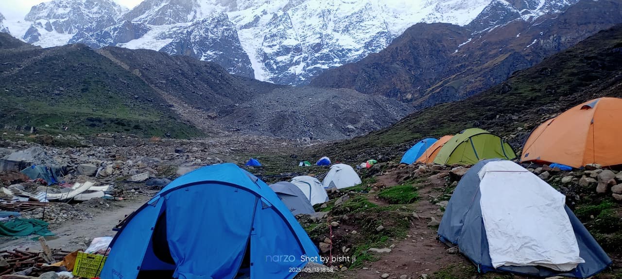
Tiwari camp
P3P9+CJJ Kedarnath, Uttarakhand 246445, India
Holy Himalayan Trekr
village karokhi post office Daira ukhimath

Tripwala Foji
Kalyanpur, Meerut (U.P), pin -250502
Kedarnath Tour Guide
Khunnu Po Guptkashi DisT Rudraprayag Uttarakhand 246439
Adventure of india
Sankri, Uttarakhand, India